SPC's new conditional intensity categories | Ep. 587 episode artwork

EPISODE · Jun 11, 2026 · 35 MIN

SPC's new conditional intensity categories | Ep. 587

from Carolina Weather Group · host CarolinaWeatherGroup.com

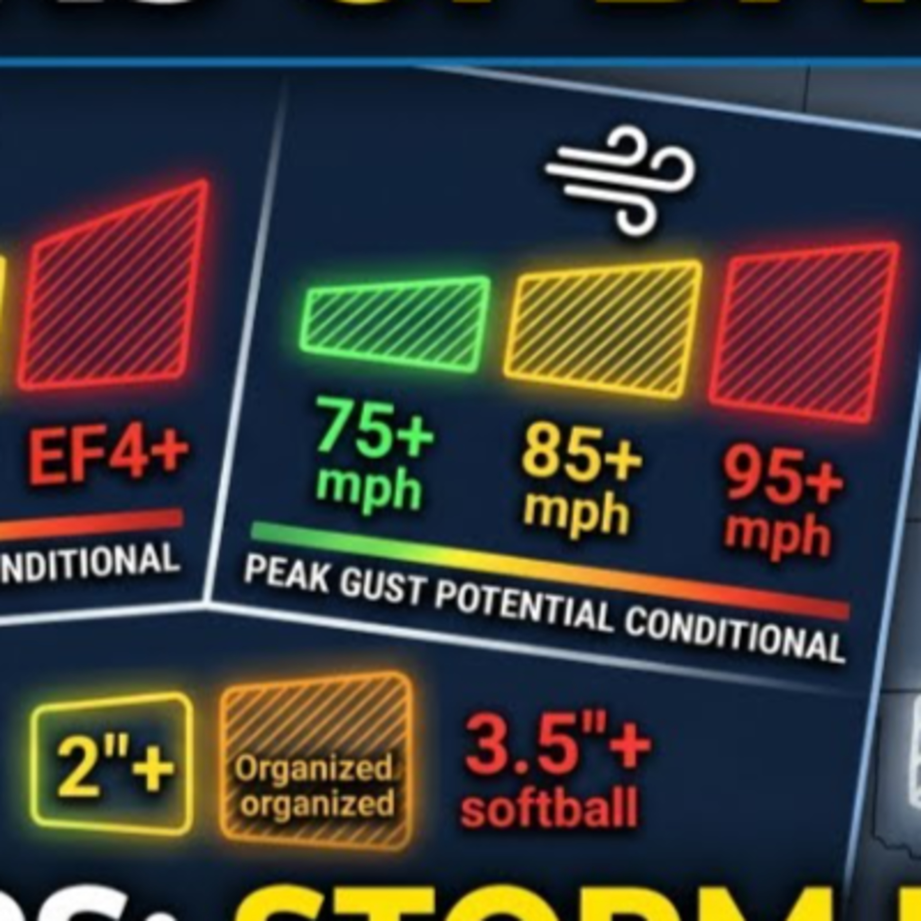
James Brierton and Greg Fishel sat down for a fascinating chat with Evan Bentley, the Warning Coordination Meteorologist at NOAA’s Storm Prediction Center (SPC). If you’ve looked at the SPC severe weather maps recently, you might have noticed some big visual updates.The SPC has officially rolled out its new Conditional Intensity Groups (CIGs)—often referred to as "Intensity Levels"—to Day 1, 2, and 3 convective outlooks.Here is a quick look behind the scenes at what this change means and what James, Greg, and Evan discussed to keep you ahead of the storm:📊 What are Conditional Intensity Groups (CIGs)?In the past, the SPC used a binary "hatched" area on their maps to indicate a 10% or higher chance of "significant severe" weather (like an EF2+ tornado, 2"+ hail, or 75+ mph winds). However, this didn't give forecasters a way to separate a common severe day from a truly catastrophic, historic outbreak without forcing you to dig deep into the written text forecast.The new CIG system replaces that single hatching with a multi-tiered intensity framework. It is conditional, meaning: “If a severe hazard occurs at your location, how intense is it expected to be?”Instead of just forecasting the chance of severe weather, the SPC can now map out the Reasonable Maximum Intensity based on the atmospheric environment and storm mode:Tornadoes (Levels 1 to 3): Level 1 points to a reasonable max intensity of an EF2 tornado. Level 2 targets EF3 potential. Level 3 is strictly reserved for those rare, violent EF4+ outbreak days (the kind of wording reserved for only one or two days a year).Damaging Winds (Levels 1 to 3): Gauges peak wind threats ranging from standard severe gusts (Level 1: 75+ mph), to organized bow echoes or derechos (Level 2: 85+ mph), up to high-end, destructive derecho events (Level 3: 95+ mph).Hail (Levels 1 to 2): Level 1 highlights 2 to 3.5-inch hail (tennis ball to baseball size). Level 2 steps up to the monster, destructive stuff—3.5 inches or greater (softball size).🗺️ The Maps Look Different, But the Risks Haven't Changed!Evan emphasized a major takeaway for our groupies: The baseline 1-to-5 risk categories (Marginal, Slight, Enhanced, Moderate, High) are NOT changing. A Slight or Moderate risk day in the future will represent the exact same historical frequency and general threat level as it did in years past.The difference is that the SPC now has a much more nuanced toolkit. For example, they can now map out a day that has a lower coverage/probability of storms but carries an extremely high-end conditional intensity if a supercell manages to breach the cap.📺 How We'll Be Communicating This to YouAs Greg and Evan talked about in the interview, looking at a map overlaid with multiple types of hatching, probabilities, and risk levels can get incredibly complicated for the public.As broadcasters and weather communicators, our goal at the Carolina Weather Group isn't to bog you down in mathematical weeds or scare you with low-context probability percentages. Instead, we'll be breaking these graphics down into bite-sized pieces: first focusing on your overall chance of being impacted, and then explicitly highlighting the areas where the worst-case scenario or higher-intensity storms are possible.#weather #northcarolina #southcarolina #ncwx #scwx #podcast📹 Join this channel to get access to perks: https://www.youtube.com/channel/UCmhGiYbMDccQcdSjpf87nGg/join🧢 MERCH: https://carolinaweathergroup.qbstores.com/💸 LEAVE A TIP: https://streamelements.com/carolinawxgroup/tip🎙️ SUBSCRIBE TO OUR PODCAST: https://anchor.fm/carolinaweather🔔 SUPPORT US ON PATREON: https://patreon.com/carolinaweathergroup💻 VISIT OUR WEBSITE: https://carolinaweathergroup.com

James Brierton and Greg Fishel sat down for a fascinating chat with Evan Bentley, the Warning Coordination Meteorologist at NOAA’s Storm Prediction Center (SPC). If you’ve looked at the SPC severe weather maps recently, you might have noticed some big visual updates.The SPC has officially rolled out its new Conditional Intensity Groups (CIGs)—often referred to as "Intensity Levels"—to Day 1, 2, and 3 convective outlooks.Here is a quick look behind the scenes at what this change means and what James, Greg, and Evan discussed to keep you ahead of the storm:📊 What are Conditional Intensity Groups (CIGs)?In the past, the SPC used a binary "hatched" area on their maps to indicate a 10% or higher chance of "significant severe" weather (like an EF2+ tornado, 2"+ hail, or 75+ mph winds). However, this didn't give forecasters a way to separate a common severe day from a truly catastrophic, historic outbreak without forcing you to dig deep into the written text forecast.The new CIG system replaces that single hatching with a multi-tiered intensity framework. It is conditional, meaning: “If a severe hazard occurs at your location, how intense is it expected to be?”Instead of just forecasting the chance of severe weather, the SPC can now map out the Reasonable Maximum Intensity based on the atmospheric environment and storm mode:Tornadoes (Levels 1 to 3): Level 1 points to a reasonable max intensity of an EF2 tornado. Level 2 targets EF3 potential. Level 3 is strictly reserved for those rare, violent EF4+ outbreak days (the kind of wording reserved for only one or two days a year).Damaging Winds (Levels 1 to 3): Gauges peak wind threats ranging from standard severe gusts (Level 1: 75+ mph), to organized bow echoes or derechos (Level 2: 85+ mph), up to high-end, destructive derecho events (Level 3: 95+ mph).Hail (Levels 1 to 2): Level 1 highlights 2 to 3.5-inch hail (tennis ball to baseball size). Level 2 steps up to the monster, destructive stuff—3.5 inches or greater (softball size).🗺️ The Maps Look Different, But the Risks Haven't Changed!Evan emphasized a major takeaway for our groupies: The baseline 1-to-5 risk categories (Marginal, Slight, Enhanced, Moderate, High) are NOT changing. A Slight or Moderate risk day in the future will represent the exact same historical frequency and general threat level as it did in years past.The difference is that the SPC now has a much more nuanced toolkit. For example, they can now map out a day that has a lower coverage/probability of storms but carries an extremely high-end conditional intensity if a supercell manages to breach the cap.📺 How We'll Be Communicating This to YouAs Greg and Evan talked about in the interview, looking at a map overlaid with multiple types of hatching, probabilities, and risk levels can get incredibly complicated for the public.As broadcasters and weather communicators, our goal at the Carolina Weather Group isn't to bog you down in mathematical weeds or scare you with low-context probability percentages. Instead, we'll be breaking these graphics down into bite-sized pieces: first focusing on your overall chance of being impacted, and then explicitly highlighting the areas where the worst-case scenario or higher-intensity storms are possible.#weather #northcarolina #southcarolina #ncwx #scwx #podcast📹 Join this channel to get access to perks: https://www.youtube.com/channel/UCmhGiYbMDccQcdSjpf87nGg/join🧢 MERCH: https://carolinaweathergroup.qbstores.com/💸 LEAVE A TIP: https://streamelements.com/carolinawxgroup/tip🎙️ SUBSCRIBE TO OUR PODCAST: https://anchor.fm/carolinaweather🔔 SUPPORT US ON PATREON: https://patreon.com/carolinaweathergroup💻 VISIT OUR WEBSITE: https://carolinaweathergroup.com

NOW PLAYING

SPC's new conditional intensity categories | Ep. 587

0:00 35:48

No transcript for this episode yet

We transcribe on demand. Request one and we'll notify you when it's ready — usually under 10 minutes.

DIOSA. Carolina Sanper This podcast is a sacred space created by Carolina Sanper where you connect with your inner wisdom and embody your magnetic feminine power.It is the realization that the mystical realm is where you plant the seeds of your desired reality.It is a portal to your true essence: awareness, presence, and receiving with ease. Welcome home, DIOSA. 🖤 Capital Ideas Podcast Capital Group Want to learn how professional investors do it? The Capital Ideas podcast brings you the latest investment thinking from Capital Group, one of the world's largest investment management organizations. Each week we'll get inside the minds of portfolio managers, analysts and economists to break down market trends, macroeconomic forces, investing approaches and lessons learned from personal experience. Take 30 minutes and tap into the intellectual capital of Capital Group. Capital Client Group, Inc.All Capital Group trademarks mentioned are owned by The Capital Group Companies, Inc., an affiliated company or fund. All other company and product names mentioned are the property of their respective companies.For full disclosures go to capitalgroup.com/global-disclosures. Sing Better Fast! | Vocal tips, singing lessons, voice exercises, etc. Jaime Vendera - Vocal Coach Wish you could sing better, higher and stronger, but don't have "natural talent?" Want some vocal tips, demonstrations, and exercise ideas? Looking for motivation and advice to become a better singer? Want to sing high in full voice without straining?Then welcome to the Sing Better Fast Podcast, a podcast by vocal coaches and authors, Jaime Vendera and Ben Valen!The Sing Better Fast podcast is exclusively for serious and passionate vocalists! You are now part of a professional group of smart and motivated singers who want to become masters of the voice and inspire millions with our music.Get all of our podcast episodes, notifications for upcoming events, new podcast releases, and other vocal resources at singbetterfast.com!

Frequently Asked Questions

How long is this episode of Carolina Weather Group?

This episode is 35 minutes long.

When was this Carolina Weather Group episode published?

This episode was published on June 11, 2026.

What is this episode about?

James Brierton and Greg Fishel sat down for a fascinating chat with Evan Bentley, the Warning Coordination Meteorologist at NOAA’s Storm Prediction Center (SPC). If you’ve looked at the SPC severe weather maps recently, you might have noticed some...

Can I download this Carolina Weather Group episode?

Yes, you can download this episode by clicking the download button on the episode player, or subscribe to the podcast in your preferred podcast app for automatic downloads.
URL copied to clipboard!