EPISODE · Oct 3, 2025 · 5 MIN
EUthMappers - learning by teaching mapping (sotm2025)
from Chaos Computer Club - recent audio-only feed · host Quang Huy NGUYEN
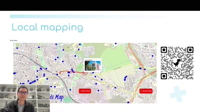
EUthMappers is an ERASMUS+ initiative that promotes STEAM education in secondary schools throughout the European Union, enhancing students' digital skills and fostering environmental civic engagement. The project includes three universities, students and teachers from five European schools, working for two years. The project has three main phases: development of training materials, local mapping projects and humanitarian mapping collaboration. This presentation outlines the project's implementation steps and showcases the remarkable results achieved by not only participating students but also organizers. EUthMappers is an ERASMUS+ initiative that promotes STEAM education in secondary schools throughout the European Union, enhancing students' digital skills and fostering environmental civic engagement. The project bridges theoretical learning with practical applications using open-source geospatial tools and collaborative mapping on the OpenStreetMap (OSM) platform. The idea is to establish an European mapping network similar to YouthMappers. This presentation outlines the project's implementation steps and showcases the remarkable results achieved by participating students. The project involves three universities (Politecnico di Milano, Universidad Politécnica de Madrid, and Presovska Univerzita V Presov) and five secondary schools located in Italy, Spain, Slovakia, Romania, and Portugal, engaging approximately 160 students in total. The management of the project is done by Euronike, which is an association expert in capacity building activities and EU policies. Until now, the project has been running for two years, and was implemented in three phases. 1. Development of training materials: a comprehensive training package on open geospatial tools and data analysis was written and made available in six languages (English, Italian, Spanish, Portuguese, Slovakian and Romanian). This training was first delivered to teachers, who then transferred the knowledge to their students. 2. Local mapping projects: under the guidance of their teachers and with university collaboration, students developed local mapping initiatives from ideation to implementation, focusing on data acquisition and visualization techniques. Across five European cities, pupils carried out mapping-focused projects that combined local engagement with practical outcomes. In Rovereto (Italy), students identified drainage channels on forest roads in the “Bosco della Città” as a central issue and mapped them using GPS and drone imagery. Since such features had never been mapped on OSM, they engaged with the OSM community to propose and share a new mapping methodology. The resulting maps and database now support both routine and extraordinary maintenance by the Rovereto Forestry Service, helping mitigate hydrogeological risks. In Madrid (Spain), pupils mapped key elements related to mobility, leisure spaces, and climate shelters in the Arganzuela neighborhood. Working in groups, they identified and analyzed public space features, and then proposed concrete improvements to enhance young people’s quality of life, which they presented at local events and forums. In Prešov (Slovakia), students focused on tree mapping in central city parks. After ecological training, they collected detailed data—such as species, trunk width, and height—using practical tools and mobile apps. Their results contributed to urban ecological databases and were showcased to the public during their school’s open-door day. In Lisbon (Portugal), pupils explored how graffiti and street art reflect local identity by mapping urban artworks around their school. Through documentation and critical analysis, they created a record of artistic interventions with social and historical value, culminating in a community event promoting dialogue on youth expression in public space. In Pitești (Romania), students diagnosed low public awareness of recycling facilities and mapped the location, accessibility, and types of waste accepted at collection points. Their interactive map aimed to make recycling easier and more visible, encouraging environmental responsibility across the city. These projects show how pupil-led mapping activities can generate innovative tools, influence local planning, and foster active citizenship. 3. Humanitarian mapping collaboration: as the final activity, students participated in a humanitarian mapping project issued by the United Nations Global Service Centre (UNGSC). There were two workshops about humanitarian mapping and Sustainable Development Goals (SDGs) in order to provide students basic knowledge about humanitarian mapping and their contribution to common goods. Students are then trained on humanitarian mapping simulation projects before actually participating in a real-world scenario proposed by UN Maps, a programme in UNGSC to enhance UN peacekeeping missions operational capabilities through open geospatial information. The training project on OSM Sandbox took place in Idlib refugee camps in Syria, while during actual project students map building data to contribute to generate a three-dimensional digital replica of the city Kandahar, Afghanistan. The generated graphical replica can be used by the UNAMA mission engaging in Virtual Reality (VR) applications to train peacekeeping officers and as a collaborative tool for security and operational briefings. This final phase expanded students' collaborative abilities beyond their classrooms to engage in a meaningful humanitarian project with international impact. Throughout these activities, students developed teamwork capabilities, creative thinking skills, and innovative data collection methodologies. Not to mention that, the project’s partners also had to think outside the box so as to deliver complicated insights particularly geospatial technology, OSM, collaborative and humanitarian mapping, to the students in the most intuitive way possible. Didactic materials have been researched and developed within the process : (A) interactive engagement tools, (B) custom OSM editors (iDSandbox4ALL and iD4ALL) designed specifically for educational contexts, (C) data visualization of student mapping results. More specifically, the interactive engagement tools have been developed to solve the problem of lack of physical interaction among the students, during the online workshop. A set of quizzes were developed, initially with simple questions, then upgraded to a discussion forum, and finally the students were driven to put their opinion on the world map. All the quizzes were programmed using Python distributed on the Streamlit platform, therefore they are easily modifiable and reusable for other educational projects. The custom OSM editors were designed to solve the digital accessibility gap and to allow an easy practice of mapping activity. Pupils are asked to work on OSM Sandbox servers in simulating projects to acquire necessary skills for the final actual project and not all the schools can provide one computer for each student. Then the application iDSandbox4ALL with a smartphone-friendly interface was developed. Subsequently the new application iD4All, with similar technical specifications for mapping in OSM has been released. Tha last teaching material is related to data statistics and visualization. A set of python notebooks for acquiring OSM Sandbox and OSM data, making statistics and deploying three dimension maps has been developed. Furthermore the work of the students with precise information of the contribution for each pupil is reported weekly. In conclusion the EUthMappers project is a mapping playground not only for students but also for educators. Through dynamic mapping activities, students collaborate to identify local and global challenges and address them using geospatial technology. Humanitarian mapping encourages students to develop empathy and participate meaningfully in global emergency initiatives. Creative Commons Attribution 3.0 Unported https://creativecommons.org/licenses/by/3.0/ about this event: https://2025.stateofthemap.org/sessions/EK9UYY/
What this episode covers
EUthMappers is an ERASMUS+ initiative that promotes STEAM education in secondary schools throughout the European Union, enhancing students' digital skills and fostering environmental civic engagement. The project includes three universities, students and teachers from five European schools, working for two years. The project has three main phases: development of training materials, local mapping projects and humanitarian mapping collaboration. This presentation outlines the project's implementation steps and showcases the remarkable results achieved by not only participating students but also organizers. EUthMappers is an ERASMUS+ initiative that promotes STEAM education in secondary schools throughout the European Union, enhancing students' digital skills and fostering environmental civic engagement. The project bridges theoretical learning with practical applications using open-source geospatial tools and collaborative mapping on the OpenStreetMap (OSM) platform. The idea is to establish an European mapping network similar to YouthMappers. This presentation outlines the project's implementation steps and showcases the remarkable results achieved by participating students. The project involves three universities (Politecnico di Milano, Universidad Politécnica de Madrid, and Presovska Univerzita V Presov) and five secondary schools located in Italy, Spain, Slovakia, Romania, and Portugal, engaging approximately 160 students in total. The management of the project is done by Euronike, which is an association expert in capacity building activities and EU policies. Until now, the project has been running for two years, and was implemented in three phases. 1. Development of training materials: a comprehensive training package on open geospatial tools and data analysis was written and made available in six languages (English, Italian, Spanish, Portuguese, Slovakian and Romanian). This training was first delivered to teachers, who then transferred the knowledge to their students. 2. Local mapping projects: under the guidance of their teachers and with university collaboration, students developed local mapping initiatives from ideation to implementation, focusing on data acquisition and visualization techniques. Across five European cities, pupils carried out mapping-focused projects that combined local engagement with practical outcomes. In Rovereto (Italy), students identified drainage channels on forest roads in the “Bosco della Città” as a central issue and mapped them using GPS and drone imagery. Since such features had never been mapped on OSM, they engaged with the OSM community to propose and share a new mapping methodology. The resulting maps and database now support both routine and extraordinary maintenance by the Rovereto Forestry Service, helping mitigate hydrogeological risks. In Madrid (Spain), pupils mapped key elements related to mobility, leisure spaces, and climate shelters in the Arganzuela neighborhood. Working in groups, they identified and analyzed public space features, and then proposed concrete improvements to enhance young people’s quality of life, which they presented at local events and forums. In Prešov (Slovakia), students focused on tree mapping in central city parks. After ecological training, they collected detailed data—such as species, trunk width, and height—using practical tools and mobile apps. Their results contributed to urban ecological databases and were showcased to the public during their school’s open-door day. In Lisbon (Portugal), pupils explored how graffiti and street art reflect local identity by mapping urban artworks around their school. Through documentation and critical analysis, they created a record of artistic interventions with social and historical value, culminating in a community event promoting dialogue on youth expression in public space. In Pitești (Romania), students diagnosed low public awareness of recycling facilities and mapped the location, accessibility, and types of waste accepted at collection points. Their interactive map aimed to make recycling easier and more visible, encouraging environmental responsibility across the city. These projects show how pupil-led mapping activities can generate innovative tools, influence local planning, and foster active citizenship. 3. Humanitarian mapping collaboration: as the final activity, students participated in a humanitarian mapping project issued by the United Nations Global Service Centre (UNGSC). There were two workshops about humanitarian mapping and Sustainable Development Goals (SDGs) in order to provide students basic knowledge about humanitarian mapping and their contribution to common goods. Students are then trained on humanitarian mapping simulation projects before actually participating in a real-world scenario proposed by UN Maps, a programme in UNGSC to enhance UN peacekeeping missions operational capabilities through open geospatial information. The training project on OSM Sandbox took place in Idlib refugee camps in Syria, while during actual project students map building data to contribute to generate a three-dimensional digital replica of the city Kandahar, Afghanistan. The generated graphical replica can be used by the UNAMA mission engaging in Virtual Reality (VR) applications to train peacekeeping officers and as a collaborative tool for security and operational briefings. This final phase expanded students' collaborative abilities beyond their classrooms to engage in a meaningful humanitarian project with international impact. Throughout these activities, students developed teamwork capabilities, creative thinking skills, and innovative data collection methodologies. Not to mention that, the project’s partners also had to think outside the box so as to deliver complicated insights particularly geospatial technology, OSM, collaborative and humanitarian mapping, to the students in the most intuitive way possible. Didactic materials have been researched and developed within the process : (A) interactive engagement tools, (B) custom OSM editors (iDSandbox4ALL and iD4ALL) designed specifically for educational contexts, (C) data visualization of student mapping results. More specifically, the interactive engagement tools have been developed to solve the problem of lack of physical interaction among the students, during the online workshop. A set of quizzes were developed, initially with simple questions, then upgraded to a discussion forum, and finally the students were driven to put their opinion on the world map. All the quizzes were programmed using Python distributed on the Streamlit platform, therefore they are easily modifiable and reusable for other educational projects. The custom OSM editors were designed to solve the digital accessibility gap and to allow an easy practice of mapping activity. Pupils are asked to work on OSM Sandbox servers in simulating projects to acquire necessary skills for the final actual project and not all the schools can provide one computer for each student. Then the application iDSandbox4ALL with a smartphone-friendly interface was developed. Subsequently the new application iD4All, with similar technical specifications for mapping in OSM has been released. Tha last teaching material is related to data statistics and visualization. A set of python notebooks for acquiring OSM Sandbox and OSM data, making statistics and deploying three dimension maps has been developed. Furthermore the work of the students with precise information of the contribution for each pupil is reported weekly. In conclusion the EUthMappers project is a mapping playground not only for students but also for educators. Through dynamic mapping activities, students collaborate to identify local and global challenges and address them using geospatial technology. Humanitarian mapping encourages students to develop empathy and participate meaningfully in global emergency initiatives. Creative Commons Attribution 3.0 Unported https://creativecommons.org/licenses/by/3.0/ about this event: https://2025.stateofthemap.org/sessions/EK9UYY/
NOW PLAYING
EUthMappers - learning by teaching mapping (sotm2025)
No transcript for this episode yet
Similar Episodes
Mar 26, 2026 ·1m
Feb 8, 2026 ·4m
Jan 30, 2026 ·6m
Jan 2, 2026 ·47m