
EPISODE · Aug 17, 2025 · 39 MIN
Hurricane Erin Update & Rapid Intensification Explained
from Meteorology Matters
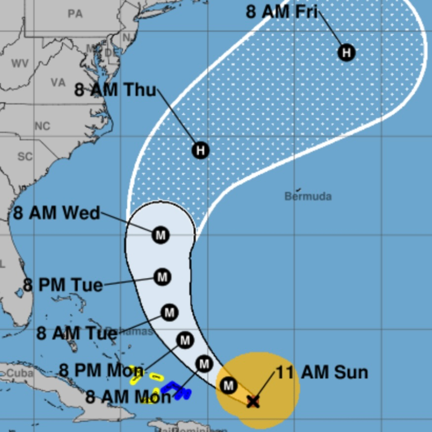
Got something to say to this podcast? Send a voicemail, and you might hear yourself on the next episode! August 17, 1025: Hurricane Erin, recently a Category 5 storm, underwent one of the fastest intensifications ever observed, reaching the second lowest pressure ever recorded for an August hurricane after Hurricane Allen in 1980. While the storm is fortunate to be on a path that avoids direct land impact, its powerful energy will still significantly affect coastal areas. Key Facts about Hurricane Erin: Intensification & Current Status: Erin rapidly intensified to a Category 5, then weakened to a Category 3 due to an "eyewall replacement cycle" which expanded its size. It is forecast to intensify again as it moves north, east of the Bahamas, and will continue to grow in circulation diameter. Offshore Track: The storm is tracking west 150 miles offshore of Puerto Rico, will turn north before reaching the Bahamas, and will pass between North Carolina and Bermuda before heading out to sea. This path is "extremely fortunate" in avoiding direct land impact. Widespread Coastal Impacts: Despite being offshore, Erin will put "a tremendous amount of energy into the ocean," affecting all coastlines from the Caribbean to Canada, including the Bahamas and the U.S. East Coast. Wave & Current Impacts: A larger diameter storm "will move more water and make stronger currents that impact the coast." Beach conditions will be affected in Florida and the Southeast on Tuesday, peaking in the Mid-Atlantic and New England on Wednesday and Thursday. Rip Current Warning: Florida, particularly from Palm Beach County north to the Georgia border, will experience noticeable effects, including the "possibility of rip currents." The rule for rip currents is to "swim parallel to the beach." Fringe Winds: Eastern North Carolina, the Virginia Tidewater, and the Delmarva Peninsula are most likely to experience "fringe effects from Erin’s winds about Wednesday," though "nothing severe is expected." Next African System: Computer models show a disturbance in the eastern Atlantic potentially developing into a "disruptive system" approaching the Caribbean islands by late week. Key Themes and Facts on Rapid Intensification: Definition of Rapid Intensification: The National Hurricane Center defines rapid intensification (RI) as an increase in wind speed by 35 mph (46 kph) in 24 hours. Doubling of Extreme Intensification: In the last 20 years (2001-2020), 8.1% of Atlantic tropical cyclones intensified from a Category 1 or weaker to a major hurricane (Category 3 or greater) within 24 hours. This rate was only 3.2% from 1971 to 1990. For a 36-hour window, the likelihood has "more than doubled" in the modern era (10.3%) compared to the historical era (4.23%). Role of Ocean Warming:Primary Fuel: "With warmer oceans serving as fuel, Atlantic hurricanes are now more than twice as likely as before to rapidly intensify..." Oceans "have been setting heat records monthly since April" with "90% of the excess warming that humans have caused to the planet going into our oceans." Scientific Consensus: "As anthropogenic emissions have warmed the planet, the world's oceans have warmed at the surface, where average temperatures have increased ~0.88 °C from 1850–1900 to 2011–2020. The rate at which ocean surfaces have warmed has also accelerated, with 0.60 °C of this warming occurring since 1980." This "simultaneous increases in both extreme SSTs and maximum TC intensification rates suggests that human-caused warming has already had a measurable impact on the speed with which TCs strengthen."
Embed this episode
Ready to play
Hurricane Erin Update & Rapid Intensification Explained
No transcript for this episode yet
Similar Episodes
No similar episodes found.