IGNIS Aerial Ignition
from The Duke Report Podcast Hosted by The Duke Report™️
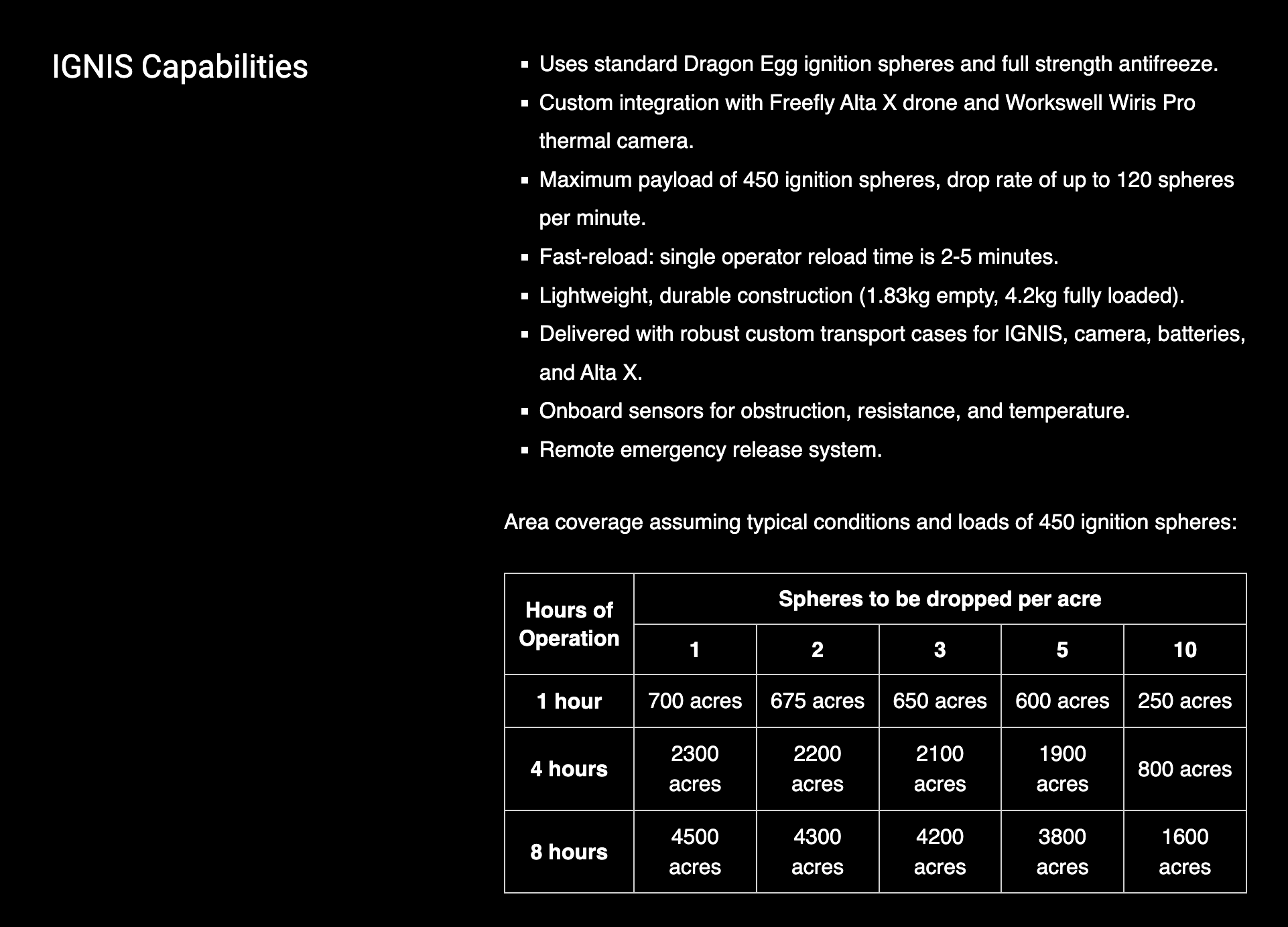
Posted without comment. (Suggested process: use your λόγος) h/t Bassehound SOURCE Burn more. Burn faster. Burn safer. Safety Fire from the air. Keep your boots on the ground. Extend your reach across the burn area. Quickly respond to changing conditions. Keep your crew out of harms way. IGNIS + Alta X IGNIS + Alta X IGNIS is a complete drone-based firefighting system. Controlled by an easy to use App and tightly integrated with the Amplified Alta X for maximum efficiency during backburn and prescribed fire operations. “IGNIS is effective for getting to those tough-to-get-to ridges or terrain that is either too dangerous or to labor intensive to burn safely.” - Steve Stroud Department of the Interior (DOI) Made for Firefighters. HOW IT WORKS Drone Amplified has transformed fire management practices with IGNIS, its flagship UAS aerial ignition technology. By employing drones to safely ignite prescribed fires and backburns, IGNIS empowers firefighters to achieve increased efficiency, speed, and safety in their operations. This groundbreaking solution keeps firefighters out of harm's way during high-risk burn operations, significantly reducing the risk of aviation-related wildland firefighting fatalities. Your Mission, Amplified Drone Amplified revolutionized aerial ignition with the breakthrough IGNIS Unmanned Aerial System (UAS) for fire management. Our experts in UAS, robotics, engineering, and computer science excel in solving complex drone integration challenges while complying with US Federal regulations. We are ready to propel your project forward. Contact us to kickstart your endeavor. Related Sources 17 Nov 2022 These fireball-dropping drones are on the frontlines of wildfire prevention Ping-pong balls and drones: Future of fire in the forest | US Forest Service IGNIS App The IGNIS App is a powerful ground control station, purpose-built for aerial ignition and other precision-critical missions. The essential tool for firefighters and pilots using PX4 based systems. Enhanced Mission Planning * Autonomous Waypoint Missions Easily plan, store, and execute autonomous waypoint missions. * Terrain-Aware Mission Planning Download and visualize elevation maps for safer, terrain-aware flight and mission planning. * Seamless Map Overlays KMZ, KML, and PDF map overlays, enhance mission planning with real-world data. Advanced Ignition Control * High-Precision Ignition Lines Achieve accurate and controlled burn lines during aerial ignition missions for optimal fire control and management. * Seamless Ignition Control Take manual control during aerial ignition operations, allowing for precise adjustments based on real-time fire behavior. * Ignition Geofence Boundary Set boundaries for ignition operations, ensuring ignitions occur only within specified areas, enhancing safety and compliance. Fly With Confidence * ADS-B In Integration Monitor other aircraft in the vicinity, maintaining situational awareness and avoiding potential conflicts during missions. * Comprehensive Flight Logging Leverage transect tools to plan precise ignition lines across your burn area. * Automated Safety Procedures Implement automated safety procedures such as Return to Home (RTH) to safeguard your drone in case of emergencies. Thanks to my readers’ generosity, all my articles are free to access. Independent journalism, however, requires time and investment. If you found value in this article or any others, please consider sharing or even becoming a paid subscriber, who benefits by joining the conversation in the comments. I want you to know that your support is always gratefully received and will never be forgotten. Please buy me a coffee or as many as you wish. Peter Tripp Akemann • SkyDance (Oracle) Exec. This is a public episode. If you'd like to discuss this with other subscribers or get access to bonus episodes, visit thedukereport.substack.com/subscribe
Embed this episode
No transcript yet.