EPISODE · Mar 21, 2014 · 25 MIN
Open-Source-Software „survey2GIS" (fossgis2014)
from Chaos Computer Club - recent events feed · host David Bibby
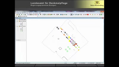
Survey2GIS ist eine kompakte und benutzerfreundliche Lösung, um Tachymeterdaten einer Grabung für die Weiterverarbeitung in einem GIS aufzubereiten. Dabei werden zwei- oder dreidimensionale Punktmessdaten zu komplexen Geometrien (Linien und Polygonen) verbunden. Als Eingabedaten erwartet survey2gis eine oder mehrere einfache Textdateien, wobei jede Zeile die Koordinaten eines Punktes und die Attributdaten hierzu enthält. Derart strukturierte Daten können nicht nur tachymetrisch per Totalstation, sondern auch per GPS-Vermessung gewonnen werden. Auf dieser Grundlage erzeugt Survey2GIS GIS-Dateien im Format ESRI(tm) Shapefile (2D oder 3D), nach Geometrietypen getrennt, mit Übernahme der vollständigen Attributdaten. Dieser Prozess lässt sich so konfigurieren, dass unterschiedlichste Arbeitsabläufe und Datenstrukturen unterstützt werden. Die Software verfügt über detaillierte Protokollfunktionen zur Qualitätssicherung und automatischen Dokumentation der Datenverarbeitung. Bei der Entwicklung von survey2GIS wurde größter Wert auf topologisch korrekte Ausgabedaten gelegt, die sich direkt für die quantitative Analyse im GIS eignen. Hierzu gehören Funktionen zum Eliminieren doppelter Messpunkte, zum Einrasten von Stützpunkten auf Polygongrenzen und zum "Ausstanzen" überlappender Polygone. Die freie Software (GNU General Public License) läuft unter Windows und Linux-Betriebssystemen. Dabei steht die erste Version 1.x von surveying sowohl als eigenständige Software als auch als Zusatz für das Open-Source-Desktop-GIS gvSIG CE zur Verfügung. about this event: https://fossgis-konferenz.de/2014/programm/events/711.de.html
What this episode covers
Survey2GIS ist eine kompakte und benutzerfreundliche Lösung, um Tachymeterdaten einer Grabung für die Weiterverarbeitung in einem GIS aufzubereiten. Dabei werden zwei- oder dreidimensionale Punktmessdaten zu komplexen Geometrien (Linien und Polygonen) verbunden. Als Eingabedaten erwartet survey2gis eine oder mehrere einfache Textdateien, wobei jede Zeile die Koordinaten eines Punktes und die Attributdaten hierzu enthält. Derart strukturierte Daten können nicht nur tachymetrisch per Totalstation, sondern auch per GPS-Vermessung gewonnen werden. Auf dieser Grundlage erzeugt Survey2GIS GIS-Dateien im Format ESRI(tm) Shapefile (2D oder 3D), nach Geometrietypen getrennt, mit Übernahme der vollständigen Attributdaten. Dieser Prozess lässt sich so konfigurieren, dass unterschiedlichste Arbeitsabläufe und Datenstrukturen unterstützt werden. Die Software verfügt über detaillierte Protokollfunktionen zur Qualitätssicherung und automatischen Dokumentation der Datenverarbeitung. Bei der Entwicklung von survey2GIS wurde größter Wert auf topologisch korrekte Ausgabedaten gelegt, die sich direkt für die quantitative Analyse im GIS eignen. Hierzu gehören Funktionen zum Eliminieren doppelter Messpunkte, zum Einrasten von Stützpunkten auf Polygongrenzen und zum "Ausstanzen" überlappender Polygone. Die freie Software (GNU General Public License) läuft unter Windows und Linux-Betriebssystemen. Dabei steht die erste Version 1.x von surveying sowohl als eigenständige Software als auch als Zusatz für das Open-Source-Desktop-GIS gvSIG CE zur Verfügung. about this event: https://fossgis-konferenz.de/2014/programm/events/711.de.html
NOW PLAYING
Open-Source-Software „survey2GIS" (fossgis2014)
No transcript for this episode yet
Similar Episodes
Apr 21, 2026 ·73m
Apr 18, 2026 ·95m
Apr 15, 2026 ·55m
Apr 13, 2026 ·68m
Apr 11, 2026 ·59m
Apr 9, 2026 ·66m